Florida Public Radio Emergency Network (FPREN) Storm Center | By Irene Sans
The same weather system that has wreaked havoc across the Central Plains will continue to bring plenty of snow across the Mid-Atlantic states and will push eastward.
Of course, for Florida, there won´t be any ice or snow with this system, but it will bring cold temperatures.
The cold weather gates will stay open for much of the week as we await another system that will bring more storms and possibly a wintry mix for parts of Florida by the end of this week. But that´s too much into the future. Let’s focus on this week´s first system.

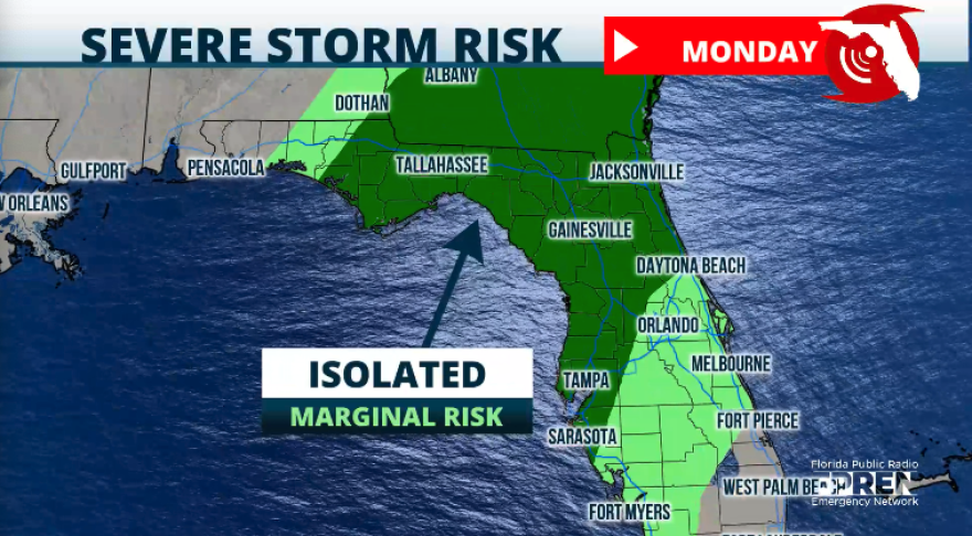
Luckily for Florida, the cold front, although still strong, is weakening as it moves eastward. There is still the chance for some isolated intense storms on Monday, especially across the central and eastern portions of the Panhandle North Florida, through the western part of the I-4 corridor. Any severe storms that get to form could produce damaging wind gusts. Remember that the risk diminishes as the front enters and moves across Florida on Monday.

Showers and storms will wind down during the day on Monday as the front pushes south. South Florida could get a stray shower, but do not expect any to be generalized. Dry air will filter in and limit shower activity across most of the region. Overall, this first cold front could bring between a quarter and one inch of rain to the Panhandle and North Florida.


The winds will be shifting promptly after the front moves through. If you are in the northern half of Florida, this will be your first sign that the severe risk is over. Once the winds start coming from the north, there will be much drier air and much cooler air to arrive.
The temperatures we mark on Monday morning will be very different from those in Florida on Tuesday morning. Skies will clear on Monday night, and cold air will arrive and sink, allowing freezing temperatures to set up camp over North Florida. Temperatures in some areas will stay as low as the mid-to-upper 20s for several hours, which could cause some freezing in crops and vegetation.


Temperatures on Wednesday morning across many places in Florida will continue to be cold. South Florida expects its coldest temperatures in nearly 2 years, all mornings of Wednesday, Thursday, and Friday. The cold air will dominate the region, and temperatures will drop to the upper 40s across many locations, including some metro areas. This means that the most frigid temperatures in January 2024 (low-50s) will finally be beaten to match the ones we had in early winter 2023.
Remember, iguanas become paralyzed once temperatures fall to the 40s and tend to fall from trees. Once the temperature rises, they can move again and go about their day. Just let them be.

What’s next this week?
The next storm system, which will arrive in Florida on Saturday, is causing a lot of buzz. Some models hint that snow could fall in parts of the state. The last snow reported in Florida was in January 2022, in Walton County in the Panhandle. Models keep going back and forth about the wintry precipitation that made it to Florida. There will still be plenty of cold air in place that would allow colder air to sink in and form any solid — or sort of solid— precipitation, but of course, there are also several days ahead of us, and any slight increase in temperatures will likely keep all the precipitation in a liquid state. Please check back for updates later this week.
Leave a Reply


