Florida Public Radio Emergency Network (FPREN) Storm Center | By Irene Sans
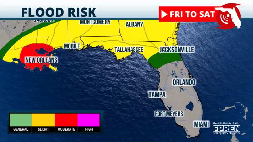
Heavy rainfall has been the norm this week across much of the state this week. The latter part of the week comes with higher than normal chances, especially over North Florida and the Panhandle where the stationary front will be barely moving on Friday. Its main movement will be from west to east dragging all the instability over the same regions. We do not expect it to clear from northern Florida until the weekend when the next cold front pushes it away from the area and drier air filters in.
Friday will be a busy day with showers and storms affecting the Panhandle overnight and through the rest of the day. The coast from Apalachicola through Pensacola could receive between 6 and 8 inches of rain through next Thursday, but the majority will fall between Friday and late Saturday. As the stationary front crawls to the east, rain chances increase over North Florida where high rainfall has been already recorded near Jacksonville received 3 inches of rain between Wednesday night and Thursday morning. On Friday there could be between 2 and 4 inches of additional rain. The rain is expected to continue at least through Saturday, therefore the National Weather Service in Jacksonville has issued a flood watch until September 7. Keep in mind that river, lake, and creek levels will continue to increase even after the rain ends.


For Central Florida, the rain will start early afternoon on Friday and intensify in the afternoon, especially if there are sunny periods before as the sun heats up the already primed atmosphere, with plenty of moisture available, sparking strong thunderstorms.
During the weekend you can count on higher-than-normal rain and storm chances as there will be a storm crossing to the north, continuing to affect northern Florida, but it comes with the next cold front that will lose speed, becoming stationary over Central Florida by the beginning of next week. This guarantees numerous storms and since the ground is already overly saturated from the recent rains this week, there will likely be more flooding developing.
Across South Florida, the storm activity will be mostly guided by the day’s heating and sea breezes. Keep in mind that on Saturday, with the winds coming from the west-southwest, the storms will be mostly focusing along the metro areas of Southeast Florida. On Sunday, there will be splattered all across South Florida, but also affecting the Southwest region of the state.
Please drive safely and stay away from flooded roads and flood waters. Flooding can be deeper than expected and a car can easily stall in less than a foot of accumulated water. Walking through flood waters can be extremely dangerous. There could be bacteria, animals, or sharp objects in the water.

Leave a Reply


