
Florida Public Radio Emergency Network (FPREN) Storm Center | By Irene Sans
River levels will continue to rise even as sunny conditions prevail across North and Central Florida. A cold front will sweep through the state, at least bringing cold and dry conditions that will help Hurricane Milton recovery efforts.
A cold front has lost its energy and drapes across Central Florida. But it is attached to another low-pressure system swinging across the northern portion of the Gulf of Mexico. This one will bring the next cold front, bringing cooler and drier air with enough energy to swipe through the state.
We do not expect rain chances to increase through the end of this week. A high-pressure system will continue to bring easy conditions through Sunday across some areas. A weak trough may increase cloud coverage and maybe a sprinkle or two along the eastern coast of Florida late Friday and Saturday. But they will be very short-lived as there are very dry conditions in the middle and upper levels of the atmosphere.
Central Florida
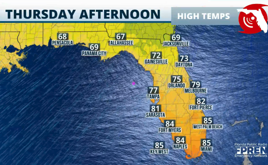
Along the I-4 corridor through the East Central coast, highs will also be in the mid-70s. There will be plenty of sunshine in the afternoon, but nights will be chilly, especially Wednesday night, with lows dropping to the mid-to upper-50s.


North Florida
Tuesday’s highest temperatures across northern Florida remained in the low 80s. But as the next front pushes through, we can expect much drier and cooler air through the end of the week. The high temperatures will struggle to reach 75°F on Wednesday and Thursday and move into the upper 70s by Friday. Gainesville’s coldest night will be Wednesday night, with low temperatures dropping to mid-upper 40s. Expect breezy conditions to stay put through the end of the week and the beginning of the weekend. Gusts could be as high as 25 mph.

South Florida
The passage of this cold front will also allow South Floridians to experience cooler conditions and dryer weather. Highs will be between the upper 70s and mid-80s, with breezy conditions dominating the region between Wednesday night and Thursday night. As the front pushes through, there’s a very low chance of scattered afternoon thunderstorms, especially on Wednesday. Thursday will be mostly stable, with a very low chance of an isolated thunderstorm. Rain chances could creep back up by Friday and Saturday as the front stays just draped along the Keys and could retract enough into Miami Dade County and produce a few isolated thunderstorms, providing a bit more clouds for the Tri-County area. Still, expect temperatures to stay in the low 80s throughout the afternoons this weekend when the conditions will also prevail with gusts that could reach up to 30 mph.

Leave a Reply


