Hurricane Helene has made landfall in Taylor County, in the Big Bend of Florida.
Winds will remain extreme over Taylor, Madison, Lafayette, Suwannee, Leon, Wakulla, and Jefferson counties for the next hour or two. The winds will gradually decrease overnight but the strong rainbands will continue to sweep through.
Please stay indoors.
Helene will move fast and stall near the Tennessee Valley during the weekend and early next week as it loses categories and moves inland over Georgia. It will fuse with another system and continue bringing rain over the Tennessee Valley for several days.
Drier air will filter in on Friday for Florida, especially for the Panhandle and northern Florida. For Central and South Florida, the last of Helene’s rainband could still be, which could produce a few storms as it will pull lots of tropical moisture from the southwest. This stream of moisture coming in from the southwest will likely stay put through the weekend.
We will have more information Friday morning. Daylight will allow us to see the damage left behind after the winds subside and the storm surge retracts. Please don´t try to pick up debris there could be live powerlines in them. If your lights are out, do not use candles. Do not use a generator inside your home, keep it 20 feet from your from., outside.
9:00 p.m. update:
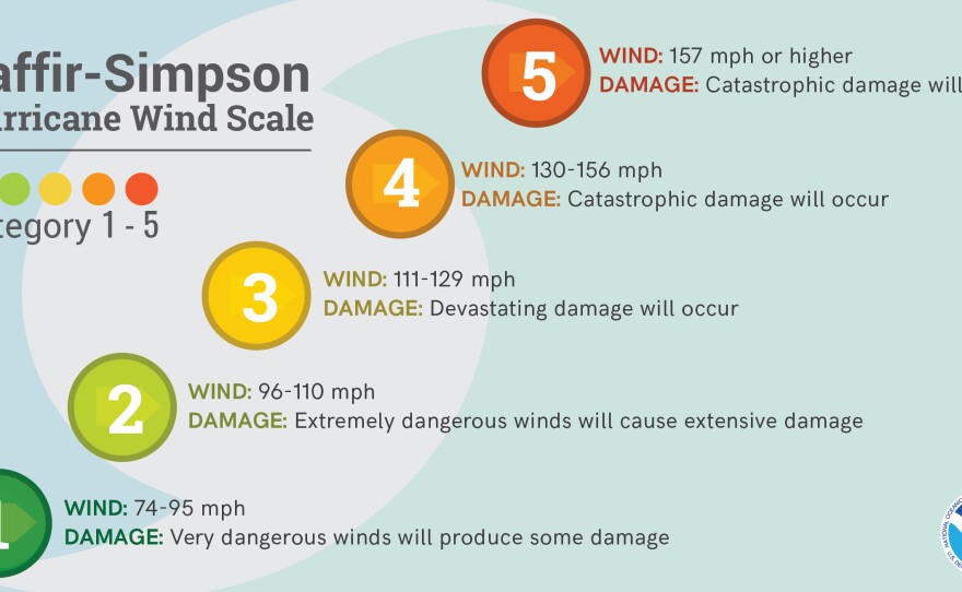
The National Hurricane Center’s latest report indicated that Helene has increased in strength once again, and its maximum sustained winds are 140 mph. The extremely dangerous hurricane is inching closer to the Big Bend coast. It is about 65 miles west of Cedar Key and 90 miles south of Tallahassee.An extreme wind warning has been placed in effect for parts of the Big Bend and Panhandle, including Tallahassee. This is because winds of at least 115 mph will be experienced within the next hour, and with this storm, sustained wind speeds will likely stay in the warned area for a couple of hours.
6:20 p.m. update:
The National Hurricane Center’s hourly updates indicate that Helene is now a category 4 hurricane with sustained winds of 130 mph. It is an extremely dangerous hurricane about 165 south of Tallahassee.
5 p.m. update: Helene’s stronger
Hurricane Helene continues to become even stronger. In the 5 p.m. bulletin, the National Hurricane Center says Helene holds maximum sustained winds of 125 mph and is moving even faster at 23 mph to the north-northeast. As the hurricane inches closer, a catastrophic and deadly storm surge will start along parts of the Panhandle and Big Bend. Large waves are already slamming against the West Coast of Florida, and waters will continue to rise as the storm moves northward.
Large wind storm Power outages have doubled in the last two hours, and over 200,000 customers are now without power. Power outages will continue to increase across the state and will be widespread across the Panhandle. Wind will quickly start to increase and penetrate across the Panhandle. Violent winds or at least 130 mph will affect the areas where the eye lands, especially to the right or east of the center.
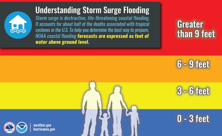
Storm Surge Up to 20 feet of storm surge is still possible across the Big Bend and parts of the Apalachicola area. Up to 8 feet of storm surge is also possible across the west portion of west-Central Florida. Flash floods likely
Rainfall will be extensive, especially across the panhandle of north Florida. Flash flooding is possible, especially as Helene inches closer. Heavy rains will continue to move up the state. Some of these heavy rains have had thunderstorms embedded in them.
The tornado watch has expired across South Florida but continues to be in effect for areas north of Lake Okeechobee.
3 p.m. update:
Helene is now a major category hurricane with maximum sustained winds at 120 mph. The hurricane continues to strengthen and will gain more speed forward. A catastrophic and deadly storm surge is forecast along parts of the Panhandle and Big Bend.
Large waves are already slamming against the West Coast of Florida, and waters will continue to rise as the storm moves northward.
Power outages are increasing across the state. Currently, over 100,000 customers are without power, most in Southwest Florida. As Helene arrives and moves through, power outages will be widespread across the Panhandle.
The previous story detailing the impacts
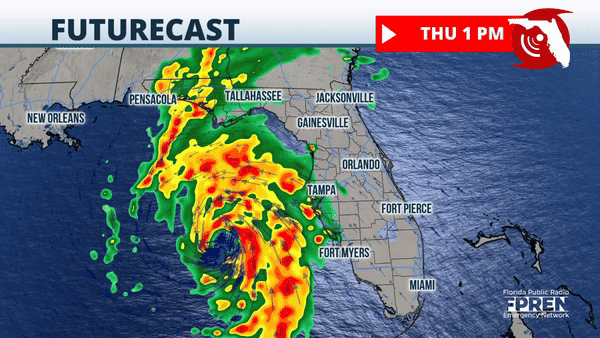
Tropical storm-force winds are experienced across southeast Florida. This means sustained winds between 39 and 57 mph. The West Coast to Florida continues to feel the upper range of tropical-storm-force winds and hurricane-force gusts. The winds will pick up promptly across northern Florida within the next few hours and will continue to become even stronger as the afternoon and evening progresses. Remember, Helene is expected to make landfall on Thursday evening in the Florida Big Bend area. Widespread power outages are very likely across the Florida peninsula and North Florida. Helene’s wind field will continue to expand as the system moves northward.
1 of 3
2 of 3
3 of 3
Up to 20 feet of storm surge is still possible across the Big Bend and parts of the Apalachicola area. Up to 8 feet of storm surge is also possible across the west portion of Central Florida.
Rainfall will be extensive, especially across the panhandle of north Florida. Flash flooding is possible, especially as Helene inches closer. Heavy rains will continue to move up the state. Some of these heavy rains have had thunderstorms embedded in them, and the National Weather Service has issued several tornado warnings across South Florida and Central Florida on Thursday morning. The tornado watch will continue in effect until 8 p.m. Thursday. Please remain indoors and continue to monitor the weather closely.
Get The Scoop from the WMNF newsroom every weekday!
Signup below to get The Scoop delivered every weekday to your email inbox.
PLEASE NOTE:
WMNF advises you to check with the individual venues or event planners listed before heading to anything posted here. There is a high likelihood that many events have been or will be canceled or postponed.
Thank you for visiting wmnf.org ~
Submit an Event
WMNF Circle of Friends
WMNF is non-commercial community conscious radio – we survive only due to the generosity of listeners like you. Please consider a sustaining monthly contribution and receive annual coupons for swag when you Join the WMNF Circle of Friends.


