
Florida Public Radio Emergency Network (FPREN) Storm Center | By Irene Sans
The tropics are quickly ramping up. We are monitoring what was called Potential Tropical Cyclone 1, which is now officially Tropical Storm Alberto, located in the western Gulf of Mexico, and an area with possible tropical development next week that could impact Florida.
Tropical Storm Alberto has made a northwestern turn after traveling north on Tuesday. This system is set to make landfall somewhere along the northeastern coast of Mexico late Wednesday or very early on Thursday morning. Although it will make landfall in Mexico, the big news will continue to emerge from Texas, as the flood risk increases, some areas could receive around 15 inches of rain in 24 to 36 hours. The south and central Texas coast started receiving rain bands late Tuesday night and some will bring big rainfall rates.

This storm is massive! It takes up a big chunk of the Gulf of Mexico, westward. Storm surge will also be a big problem. The system is not organized and it won´t likely become organized and remain very broad, also expanding the storm surge risk along the Texas coast through the coast of Louisiana. Alberto is a classic example of why people should not just focus on the cone. There will be impacts over 400 miles from the center’s landfall spot.
Another tropical disturbance brews. This one could impact Florida.
For some days now models have been hinting at the possible development of a tropical disturbance traveling a few hundred miles north of the central Caribbean, but over the Atlantic, just east of the Bahamas. This weak low-pressure system has a low chance of developing within the next few days. It is set to approach the Southeastern coast of the U.S. by Thursday. Conditions are not favorable for this system to grow by then, as there is strong wind shear not allowing this system to organize, and we do not forecast the conditions to change in time before it moves closer to land.
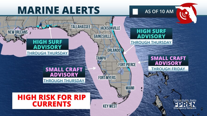
An uptick in shower and thunderstorm activity is expected from this system from Northeastern Florida through South Carolina on Thursday into Friday. The East Central Florida Coast through the Northeastern Coast could receive up to 2 inches of rain, similar amounts for the immediate southern portion of the South Carolina Coast. The wind could be gusty at times, but not too different from how it has been the last couple of days along the coast. The biggest threat will be in the marine area where strong rip currents will continue to be present as well as very rough seas. This will not be the best beach week and possibly weekend for swimmers.
The team of meteorologists at Florida Public Radio Emergency Network continues to watch the tropics closely. We will bring you updates on the Florida Storms App and your local NPR radio stations.


